So you know that your phone always knows where you are.
Not only just city.
Or not just street.
But few meter within of your exact location.
Everything is happening silently, constantly and with in second like instantly. There is no map or anything downloaded from space. There is no camera following or no signal is sending upward for asking something like “Where am I?”
But instead of this our phone is listening to whispers from satellite present in orbit of Earth and then turn time itself into distance.
Today GPS feel are felling very ordinary but behind every location pin there is so much physics, mathematics, and space technology. And once when you understand how GPS is working then you will never see at blue dots as are you seeing today.
Let’s uncover this unseen science behind GPS.
What GPS Really Is
GPS stands for Global Positioning System and its name hide its true nature.
GPS is not a single device or an app.
It is a global time-measuring machine which is spread across whole space.
This system have:
- More than 30 satellites present in orbit of Earth
- Ground control stations which monitor them
- Receivers like which we have inside our phone
Each GPS satellite is continuously broadcasting two main critical pieces of information:
- Its exact position in space
- Precise time when signal was sent
Our phone do not transmit anything back to the satellites. It is completely passive and It only listening to satellites.
This only one detail is foundation of everything which follows.
GPS Is Really About Time, Not Maps
Most people think GPS are working by comparing maps but no It doesn’t.
But GPS are working by measuring time delays with so much extreme precision.
Radio signals travel at speed of light which is about 300,000 kilometers per second so even a very tiny delay of a about few billionths of a second can be translated into meters of distance.
When a GPS satellite sends a signal it includes a timestamp and our phone then receives this signal with a slightly delay. Then our phone determine how far satellite is by calculating how much time signal took to arrive.
Distance = time delay × speed of light.
It means GPS have not calculated position first.
It only calculates have distance from multiple points then lets geometry do rest for finding position.
Why GPS Satellites Use Atomic Clocks
Here is a problem with satellites for finding current time.
Time must be measured very very accurate with extraordinary precision for GPS for working with accuracy. Even if our phone clock were off by just one millisecond then difference between our location will be wrong by hundreds of kilometers.
This is why GPS satellites have atomic clocks.
Atomic clocks don’t measure time by using gears or vibrations. They measure time by natural oscillations of atoms which are astonishingly stable and these clocks are accurate within billionths of a second.
While on the other hand our phone have an ordinary clock so this difference also matter.
So for correcting it GPS uses multiple satellites which automatically correct our phone’s clock error automatically.
How GPS Calculates Our Position Step by Step
Our phone needs signals from at least four satellites for determining position and each one them play a role.
Step 1: Measuring Distance From Satellites
As soon as our phone receive signals it calculate how far each satellite is by signal delay.
Each distance form an invisible sphere around a satellite and we can be anywhere on this sphere.
One satellite give us a sphere.
Two satellites give us an overlapping circle.
Three satellites narrow it down for two possible points.
Step 2: Pinpointing Location With Four Satellites
This fourth satellite solves two problems at once:
- It eliminates incorrect location
- It also corrects your phone’s clock error
With this four satellites our phone can determine:
- Latitude
- Longitude
- Altitude
- Precise time
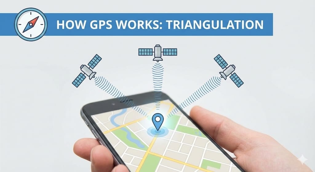
This process is called trilateration, not triangulation. This distinction matter because GPS uses distance measurements not angles.
Step 3: Refining the Final Position
This raw GPS data alone is not always enough for perfect position and especially in cities or indoors.
So for improving accuracy most modern smartphones combine GPS with:
- Mobile network data
- Nearby Wi-Fi signals
- Motion sensors like accelerometers and gyroscopes
This fusion allows our phone for having a stable location even when satellite signals weaken.
Why GPS Accuracy Changes
You must have noticed GPS accuracy varies which depend on where you are.
This happens because the time when GPS signals reaches at Earth they become extremely weak. Because there can be many factors which affect them.
Common sources of inaccuracy:
- Tall buildings reflecting signals
- Dense tree cover
- Thick walls and underground spaces
- Atmospheric conditions
In cities signals sometimes bounce between buildings before reaching our phone so this creates a small timing errors and here time is distance so it translate into position errors. This phenomenon is often called “urban canyon” effect.
Why GPS Struggles Indoors
GPS satellites are powerful but you know planet is so much complex and so objects on it.
So at the time when signals reach at Earth they become weaker than background noise of everyday electronics and walls, concrete, and metal easily absorb or distort them.
This is main reason why:
- GPS works best outdoors
- Accuracy drops inside buildings
- Indoor navigation relies on Wi-Fi and Bluetooth
So when your phone switches from GPS to Wi-Fi positioning for indoors then it’s not failing It’s just adapting for circumstances.
The Hidden Role of Einstein’s Relativity
Here is thing which will quietly bend you bend.
GPS will not work at all without corrections which come from Einstein’s theory of relativity.
GPS satellites:
- Move very fast relative to Earth
- They experience weaker gravity than we do on the surface
So according to relativity both factors are causing time to pass at different rates so Satellite clocks tick slightly faster than clocks on Earth.
This difference is very small but it adds up too so if we don’t correct it then it will create a GPS error of several kilometers every day.
So Engineers adjusted satellite clocks in advance for solving it. GPS is one of few technologies where relativity is not theoretical but It is practical.
Why GPS Is More Than Navigation
GPS is quietly supporting much more than maps and directions.
It powers:
- Ride-sharing and delivery services
- Emergency response systems
- Aviation and maritime navigation
- Financial transaction timing
- Power grid synchronization
- Scientific research and weather prediction
Whole GPS system is relying on timing not on loaction. If GPS were fail globally then you can feel it in modern infrastructure immediately because most services will be effected.
Privacy and Location Awareness
GPS itself never track you.
Our phone calculates its own position locally and tracking happens only when apps access and store that data.
So there is a distinction matters. GPS provides only ability to know your location and How that information is transferring and sharing only depends on software, permissions, and policy.
So now you can have a clear understanding of how GPS is working and what is happening and what is not.
Why This Technology Still Amazes
Every time when you see a location pin now remember what it had to align for you to appear:
- Atomic clocks in space
- Signals traveling at light speed
- Relativistic corrections
- Mathematical precision
- Sensors in your pocket
everything is happening in seconds, silently, thousands of times a day, and for billions of people.
That blue dot is not so simple as it seems.
It is a triumph of modern science a lot of work.
A Question to Leave You With
If everything just can be determine by just time for where you are then is location really about space or it is about how precisely we are measuring time?